
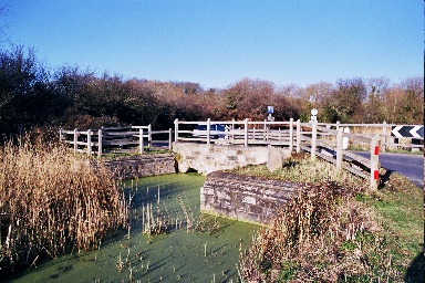
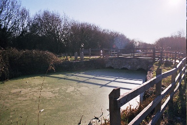
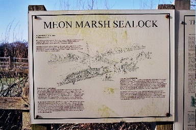
The sea lock to the Titchfield Canal
The Stubbington and Hill Head History Society |
HOME ~ OBJECTIVES ~ CONSTITUTION ~ COMITTEE ~ MEETINGS ~ PUBLICATIONS ~ MEMBERSHIP ~ OUTINGS & VISITS ~ RESEARCH ~ LOCAL FEATURES ~ LOCAL PEOPLE |
|
The sea lock to the Titchfield Canal |
 |
 |
 |
|||
| Very little is known about
this waterway; it does not appear in the standard canal history books.
There are those that claim that the canal was not intended for
navigation but was built as an irrigation or drainage ditch. It seems
that there is little firm evidence one way or the other. In medieval
times, Titchfield was a market town and port at the head of navigation
on the west bank of the tidal River Meon. The small town/village lies
about two miles upstream from The Solent. It seems that by the beginning
of the seventeenth century, silting was making navigation of the estuary
increasingly difficult. For this and other reasons, trade in Titchfield
was declining. In 1537, upon the Dissolution, land that included Titchfield Abbey was given to Thomas Wriothesley. A loyal servant of the crown, he was knighted in 1544 and three years later became Earl of Southampton. The third earl, Henry, was associated with Shakespeare and also became involved in Catholic plots against Queen Elizabeth I. He spent several years in the Tower before being released by James I. He was responsible for a number of developments in the Titchfield area: the building of ironworks at Funtley, Stony Bridge across the river near the Abbey, and the market hall in the town. He was also responsible for a full scale survey of the area from which a map was drawn up in 1610. The biggest work, however, was the construction of a dyke or dam across the mouth of the Meon at Hill Head making the river non-tidal. This part of the river is still called Titchfield Haven. The estuary of the river was about 600 yards wide and, although the mouth may have been partially blocked by a natural shingle spit, this was still a substantial undertaking. The work was carried out by Richard Talbottes and was completed in 1611. At the same time the Titchfield Canal, or 'New River' as it was originally known, was also built. There is scant information about the exact reasons for building either the dam or canal. However, the result was that the estuary was flooded with fresh water, the level being controlled by sluices in the dam. This led to rapid silting up which created a large area of fertile land, which could be irrigated and flooded at will. It would appear, but is by no means certain, that the canal was constructed to maintain trade to the town and local industries. It runs along the west side of the Meon Valley just a few feet above mean sea level. Old maps show a small inlet at Meon Shore on the west side of the estuary from which the canal ran. The dimensions of the waterway mean that sea-going vessels could not have navigated to Titchfield, so transhipment to small barges would have been necessary. Obviously, such an arrangement would not be as convenient as prior to construction of the dam. No details have been discovered about the sort of boats that might have used the canal. By the eighteenth century, records state that no navigation was possible leaving it serving as an irrigation ditch. With acknowledgements to Peter Oates of the Southampton Canal Society |
|||||